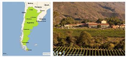
Argentina Geography
According to Areacodesexplorer, Argentina is the second largest country in South America and covers an area of around 2.8 million square kilometers. There are 3694 km between the northern and southern borders and about 1,423 km between the westernmost and easternmost point. In the east Argentina is bordered by the Atlantic Ocean, in the west by Chile, in the north Bolivia and Paraguay in the northeast border Brazil and Uruguay on Argentina.
Here is an accurate topographic map of Argentina.
The western border is taken in the Andes region, the world’s longest continental mountain range. The highest point is the Aconcagua with 6962 m, it is located near the border between Argentina and Chile in the province of Mendoza. The Argentine Andes are also home to the two highest volcanoes on earth, the 6,880 m high Ojos del Salado and the 6,795 m high Monte Pissis.
The Gran Chaco, a hot dry savannah, is located in the central north of Argentina. In the east of the Gran Chaco, the hill country of the province of Misiones stretches along the Río Paraná. The Iguazú waterfalls, which are among the largest in the world, are located in the tri-border region of Argentina, Paraguay and Brazil.
Further south, between the great rivers Rio Uruguay and Río Paraná, the swampy and humid Mesopotamia extends. The capital of Argentina, Buenos Aires, in the province of Buenos Aires of the same name, lies on the Río de la Plata, the common confluence of the two rivers mentioned. This region represents the economic heart of Argentina. About a third of the Argentines live here.
In the west and south of Buenos Aires are the pampas, grassy plains where most of Argentina’s agricultural products are produced. You will find here mainly wheat fields and huge pastures for cattle, whose meat is still one of Argentina’s main exports.
The mountain ranges of the Sierras Pampeanas are located in central Argentina between the extensive pampas and the mountains of the Andes. At their highest points, these mountains reach heights of around 2,800 m in the Sierras de Córdoba and even up to 6,250 m in the Sierra de Famatina in La Rioja.
The very sparsely populated Patagonia in southern Argentina makes up about a quarter of the country’s area and is characterized by a harsh climate with strong westerly winds. The lowest point in America is in Patagonia – the Laguna del Carbón at 105 m below sea level. This point is between Puerto San Julián and Comandante Luis Piedra Buena in the province of Santa Cruz.
Argentina claims a sector of the Antarctic.
Mountains and waters in Argentina
In the Argentine Andes, numerous mountains reach heights of more than 6,000 m. The highest mountain in America, the Aconcagua measures 6,962 m, the two highest volcanoes on earth, the Ojos del Salado 6,880 m and the Monte Pissis 6,795 m. In the southern Andes the heights are lower, but due to the cold and humid climate, many mountains are still covered with snow.
Also in the Sierras Pampeanas very high altitudes are sometimes reached: in the Sierra de Famatina in the province of La Rioja more than 6,000 m are measured. This massif drops to the east, in the Sierras de Córdoba another 2,800 meters are reached.
The Patagonids in the north (Mesetas Patagoniens) measure 4,700 m southeast of Mendoza, to the southeast the heights decrease more and more. In the other regions of Argentina, heights of more than 1,000 m are rarely reached. The Sierras Australes Bonaerenses (Sierra de la Ventana and Sierra de Tandil) on the coast of the Atlantic Ocean as well as the hills and mountains of Misiones should be mentioned here.
The hydrology in Argentina is determined by the tributaries of the Río de la Plata. Its catchment area takes up about 5,200,000 km². A third of it is on Argentine territory, the rest is shared between Bolivia, Uruguay, Praguay and Brazil. Significant tributaries of the Río de la Plata are above all the Río Paraná and the Río Uruguay. The Iguazú National Park is located in northern Argentina, on the border with Brazil. The Iguazú River flows here with the Iguazú Waterfalls, which are three times the size of Niagara Falls.
The second largest catchment area is flowed through by the Río Colorado in northern Patagonia, whose most important tributary, the Río Salado del Oeste, drains a large part of western Argentina. However, a significant proportion of the transported water evaporates due to the dry climate or seeps into swamp areas.
There are two larger lake areas in Argentina. The largest is at the foot of the southern Andes. A long chain of meltwater lakes stretches here from the province of Neuquén to Tierra del Fuego. In addition, in the western central pampas and in the south of the Chaco there are many flatland lakes that are sometimes only a few meters deep and often salty.
Among the most important lakes in Argentina is the flatland lake Laguna Mar Chiquita in the province of Córdoba with 5770 km² and the Andean lakes Lago Argentino (1415 km² area) and Lago Viedma (1088 km² area). Both lakes are part of the UNESCO World Heritage Site of the Los Glaciares National Park. One of the attractions there is the Perito Moreno glacier.